
Geohazard Assessment of A Lake Dam in Texas by Acoustic Multibeam Survey
Background
In order to perform a geohazard assessment, such as detecting and evaluating erosional and depositional patterns, across the dam area of a lake in Texas, SDI conducted an acoustic multibeam survey in 2017.
Survey
A Teledyne Odom ES3 multibeam echosounder was adopted to carry out the acoustic survey. The multibeam echosounder operates at a frequency of 240 kHz and emits 480 sonar beams over a swath width of 120 degrees. The multibeam echosounder was equipped with a Hemisphere S320/ A325 RTK GPS GLONASS base survey system for DGPS corrections. Water elevations were obtained by using a base station to acquire position data for more than 2 hours and then sent to NOAA for an OPUS solution.
The multibeam system was mounted on the 20-feet pontoon boat, tested, and calibrated before conducting the survey. The calibration involved determining the precise pitch, roll, and yaw angle offsets of the mounted system by using SDI manufactured MRU 333 motion reference unit. Since the speed of sound varies with water temperature, pressure, and salinity, the speed of sound through the water column is measured throughout the multibeam survey. A Teledyne Odom Digibar Pro profiling sound velocimeter was lowered and raised through the water column and measured the sound velocity at 0.5-meter increments. Several sound velocity casts were made by YSI Castaway CTD in the beginning of the survey to check and confirm the reproducibility of the velocity profiles.
Data streams from the GPS (position and heading), motion reference unit, velocimeter and echosounder were then integrated into a computer running a hydrographic survey software HYPACK 2017. During the multibeam data acquisition, HYPACK is used to control real-time navigation, ensure the efficient collection of bathymetric points at a given grid resolution and data logging. Fine resolution matrices were used to ensure high spatial resolution to investigate depositional and erosional feature such as scours at the survey site.
Equipment Used
- Teledyne Odom ES3 multibeam echosounder
- SDI MRU 333 motion reference unit
- YSI Castaway CTD
- Hemisphere S320/ A325 RTK GPS GLONASS base survey system
- 20-f00t Pontoon Boat
Results
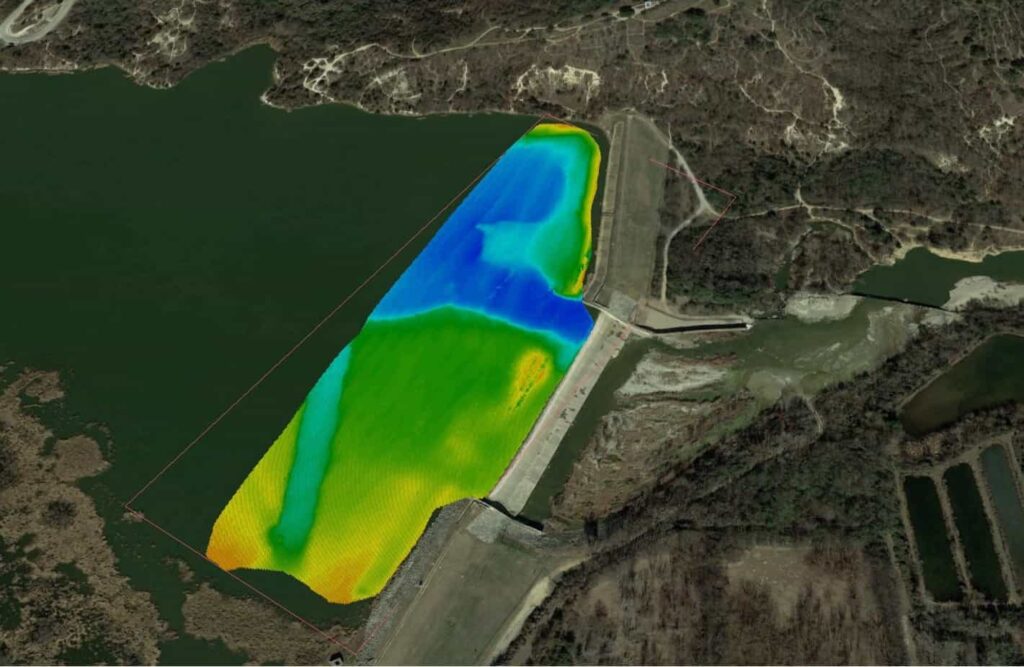
Collected raw multibeam data, as well as the angular correction from the patch test and other parameters, were input into the HYPACK for data processing. The raw data was manually edited to remove obvious outliers caused by erroneous echosounder returns. The bathymetric points collected in the study area were then resampled to a 3-feet by 3-feet grid. Each point in the grid is the average depth of all soundings collected in the 3-feet × 3-feet area or cell. The location of each point is the center of the grid cell. Below is a bathymetry contour plot was generated along with the XYZ points of the survey site.


Leave a Comment